
This is a dispatch from Constantino Panagopulos, a science writer at the Jackson School of Geosciences, who is documenting the TERMINUS mission to explore Greenland glaciers from underwater. The mission is led by Professor Ginny Catania and collaborators. Learn more about it here.
The drone’s blades buzz to life and it shoots up into the overcast sky. I track it as it climbs but it’s soon lost over the glacier ahead of us.
“You won’t see it, it’s 500 meters high, but don’t worry it’s out there,” says Marcy Davis, an engineering scientist on the TERMINUS Greenland research project and one of the drone pilots today. “It felt pretty scary the first time. You get used to it.”
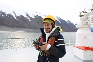
I’m on the bow of the research vessel Celtic Explorer with Davis and another TERMINUS researcher, Benjamin Keisling. Keisling has taken over piloting duties from UT Jackson School of Geosciences graduate student, Casey Vigilia who rotated off the vessel when Keisling and I joined.
In those first two weeks, Vigilia earned herself the reputation of a fearless drone pilot while conducting the team’s first aerial surveys of the glacier. According to Davis, Vigilia’s enthusiasm with the drones helped turn them into what TERMINUS chief scientist Ginny Catania considers “the sleeper stars of the expedition.”


Vigilia left behind big boots. But Davis, Keisling and another drone pilot, Dan Duncan, are doing their best to fill them. Davis, Keisling and Duncan are all scientists with the University of Texas Institute for Geophysics, which is leading the TERMINUS project
It’s a windy day over Kangerluarsuup Sermia, the second glacier the TERMINUS researchers have come to survey as part of their pioneering mission to investigate the underwater walls of Greenland’s glaciers.
Keisling, who’s monitoring the controller, has sent the drone to a higher altitude where the air is calmer. From there the drone will proceed about 4 kilometers inland, following the path of the glacier to the ice sheet. Along the way they spot glistening meltwater lakes atop the glacier. They think these lakes likely feed meltwater rivers under the ice that flow all the way to the sea where the water is flushed out in large sediment-laden plumes.
The controller shows a beautiful top-down view of the ice, it’s super-high-resolution camera picking up tiny details. Keisling switches it to show what one of the four side-mounted cameras sees. The feed abruptly turns gray and bumps around erratically. There’s good reason the scientists have dubbed it “Blair Witch-mode.”
He’s demonstrating both how much the drone is being thrown around by the wind, and how good the top-down camera system is at compensating for it.
Although small, the drones have held their own in most conditions the scientists have encountered so far over Greenland. Their onboard camera array mapped vast tracts of the glacier’s front, not just directly from above but at an angle that allows them to see depth and develop 3D digital terrain models of the icy landscape.

That’s useful because they can repeat the surveys and see how the glacier moves up and down indicating where it’s floating, or where it may have stalled as it flows downhill.
“The drones have taken on some roles that were unexpected,” Keisling tells me. “For example when we deployed the XOcean sea drone, we were able to follow it and let it know when there were icebergs in the vicinity. And that kind of reconnaissance has been true for NUI as well.”
NUI, or Nereid Under Ice, is a robot submersible developed and operated by Woods Hole Oceanographic Institution that the expedition scientists have brought with them to map the glacier underwater. Doing that could help answer questions about how glaciers melt that will hopefully lead to a better understanding of how future sea level rise will pan out.

Keisling explains that with the help of the drones, the UT researchers have supported the NUI team with on-the-fly maps of the glacier’s edge. That’s valuable for helping NUI safely get as close as possible to the glacier because the ice is constantly on the move. The glacier moves about 5 meters per day, shedding vast icebergs on an almost daily basis.
The next day, the Celtic Explorer has returned us to Kangerlussuup Sermia – the first glacier the team visited. The weather is much calmer and the drone zips through the air like a hummingbird.
When Vigilia and Davis first mapped this glacier two weeks ago, they captured videos of seals playing in the glacier’s sediment plumes. Now however, the fjord has filled with ice and there’s no sign of the seals. A serene silence surrounds the vessel broken only by the occasional deep crack of ice shifting somewhere out in the glacier.
Looking out at where the drone should be we spot movement in the mountain overlooking the fjord. The front of a mountain glacier breaks off and crashes into the sea, turning to white powder as it falls. The avalanche rumbles like thunder, then the fjord falls silent again.
“It looked so powerful I that thought snow dust might rush over the water and make it all the way to the boat, but it didn’t get anywhere near us,” Keisling said. “It’s really hard to grasp scale when you’re looking through this little controller.”
This is the fifth dispatch on the mission. To see the rest, visit the TERMINUS mission blog.
