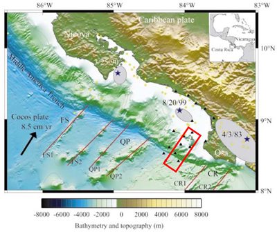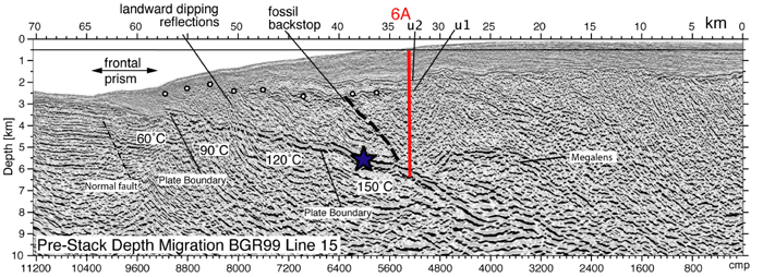
The University of Texas Institute for Geophysics (UTIG) Costa Rica 3D seismic imaging project is examining the progressive changes in structural and physical properties along the earthquake prone subduction zone off southern Costa Rica using 3D seismic imaging. The team is targeting a zone where the plate boundary undergoes a transition from stable sliding near the trench to unstable sliding (seismogenic behavior) at depths 5-6 km sub seafloor.
In contrast to seismogenic zone development at many convergent margins, this margin is erosional, so material in the plate boundary zone undergoing the transition is expected to include erosional products rather than primarily underthrust oceanic and trench sediments. The mode(s) of subduction erosion here are not fully understood, but may include detachment of large blocks of the upper plate (megalenses), “buzz saw” abrasion related to subducted horsts and grabens, overpressured fluids that hydrofracture material at the base of the upper plate, or combinations of all such processes.

Because of the multiple processes, compositions, and structure along the plate interface that are inferred in erosional environments, the team expects significant variation in the transition from stable to unstable sliding that will directly affect the patterns of micro-seismicity and in the nucleation of large earthquakes.
For example: in an erosional setting, is the transition gradual or abrupt, linear or patchy, fixed or varying? The processes of erosion imply different paths in the transition to seismogenic behavior by comparison with accretionary margins, so a major focus is to document the active erosional modes that impact seismogenesis. The combination of advanced seismic reflection and drilling techniques that are planned and will be applied to the Costa Rican area will certainly advance not only a local understanding but an understanding of the broad scope of seismogenic processes in the framework of seismogenic investigations on the San Andreas Fault and the Nankai subduction zone.
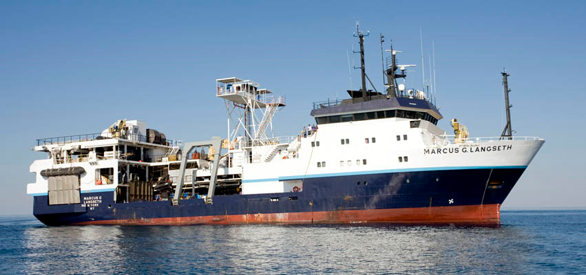
The team will image the structures within this transect in great detail with state-of-the-art techniques. In 2011, they were able to survey a 12 x 55 km area with the R/V Marcus Langseth and acquired excellent data for the survey objectives. Repsol, Spain’s largest oil company, has generously offered their facilities in Madrid for the prestack processing. With the team’s oversight they will conduct all of the necessary preliminary processing in Spain. The plan is to then do state-of-the-art prestack depth imaging in Houston (also at Repsol) and at University of Texas at Austin. This project will result in an excellent 3D image volume showing key structures of the plate boundary zone and upper and lower plates. The team will also extract substantial data on fault zone physical properties, which will provide critical results for understanding seismogenic behavior in an erosional setting and critical data for further investigations with Integrated Ocean Drilling Program riser and non-riser drilling through the CRISP drilling program.
Participants
University of Texas Institute for Geophysics – Nathan Bangs and Kirk McIntosh
University of California, Santa Cruz – Eli Silver
United States Geological Survey – Roland von Huene
ICREA at the Spanish National Research Council in Barcelona, Spain – Cesar Ranero
Figures

![Figure [A] shows depth image across the location of proposed drill sites. Shallow, non-riser sites are shown in orange and deeper riser holes in red. Note that drilling of the deepest hole will penetrate the nucleation area of the 2002 Mw6.4 earthquake (approximate location shown by blue arrow). Figure [B] is a diagram of main geological units, based on the seismic image of Figure [A], showing the plan to drill on either side of the updip limit of the seismogenic zone.](https://ig.utexas.edu/wp-content/uploads/2015/11/costarica-image2.jpg)
