
Background
Subduction zones are settings where one plate slips beneath another along a subduction megathrust fault as it moves back into the mantle. Around the world subduction zones generate over 90% of the world’s seismic energy and produce the most powerful and destructive earthquakes and tsunamis. While most subduction thrust faults along some subduction zones accumulate strain over hundreds of years and release it in a matter of seconds to minutes during great earthquakes, such as the 2011 Tohoku earthquake and tsunami, the 2004 Sumatra event, and the 2015 and 2010 Chile events, others release the accumulated strain less destructively through other fault slip mechanisms. One such recently discovered slip mechanism is slow slip rupture, where strain energy is released during slip that occurs over periods of weeks to months. What controls fault slip behavior is virtually unknown but is critical for understanding and assessing global seismic hazards.
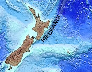
The subduction zone along the east coast of the New Zealand North Island regularly (~ every 4 years) produces unusually shallow slow slip earthquakes. These earthquakes occur as shallow as 4-5 km below the sea surface, unlike other known slow slip fault systems in SW Japan or the Cascadia subduction zones, where slow slip occurs at 30+ km depth. Because of this, the earthquakes near New Zealand North Island are some of the best documented slow slip earthquakes in the world.
This project would conduct a 3D seismic survey designed to image the New Zealand subduction zone structure and map subduction zone fault systems to determine the faulting network and its interaction with the subduction megathrust. We would also be able to measure physical conditions along the subduction zone megathrust fault to determine what conditions are associated with slow slip behavior, how they differ from conditions associated with subduction zones that generate great earthquakes, and what controls the development of slow-slip faults instead of earthquake prone faults.
In early January 2018, we would set sail on the R/V Langseth to acquire a 3D seismic reflection data set in a 15 x 60 km area offshore New Zealand’s Hikurangi trench and forearc. We would tow 4-6,000-meter-long seismic streamer spaced 150 apart, each with receivers spaced at 12.5 m that would image a 300 m wide swath of the subsurface with each pass through the survey area. We would use two seismic source arrays and release the source signal alternately from one then the other every 37.5 m along the track. These data would be used to construct images of the sub-seafloor structure that can be interpreted to map faults, deformation patterns, fluid migration, and properties of the sub-seafloor material such as density and porosity to infer rock types, fluid migration, and potentially identify areas of high fluid pressures within the rocks. These data would complement an upcoming International Ocean Discovery Drilling program that would drill in the 3D survey area to recover rocks that we would image on our 3D seismic images. The combined seismic images and drilling results would allow us to conduct a broad assessment of characteristics of the rocks that cause slow-slip rupture along the Hikurangi margin and allow us to understand earthquakes in subduction zone settings all over the world.
Research Team
Meet the researchers working on this proposal.
Project Components
Coming soon
Field Work
Coming soon
Data
Coming soon
Go back to the main Hikurangi Subduction Zone Seismic Studies page.