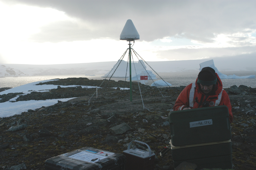
In November 2002, UTIG researchers Fred Taylor, Cliff Frohlich, and graduate student Kris Gudipati, embarked on a NSF-funded project to study microplate motions in Antarctica using global positioning system (GPS) instruments. Neither Frohlich nor Gudipati had been to Antarctica previously. During the five-week field program aboard the research vessel Laurence M. Gould, Frohlich sent a series of letters and photographs to his friends and family describing what it was like to participate in this project. Published here, the letters and their belong to UTIG Senior Research Scientist Emeritus Cliff Frohlich.
From Cliff Frohlich, 26 November 2002
Dear family & friends –
It is 6 AM here, and I just finished taking a water sample for the Princeton group. I’ll take another in about an hour. We are two-thirds of the way across the Drake Passage, and late today we reach Smith Island, where, if the seas cooperate, Fred, Kris and I will deploy the first GPS site.
As you may know, the Drake Passage is infamous for routinely having some of the worst weather conditions anywhere; moreover, since we head north-south and the winds tend to go east-west, the ‘word on the street’ (ho ho) is that the ship can’t avoid rolling more than it would if we could head into or with the wind. Thus, before we entered the Passage everybody but me was gulping great quantities of seasick pills, and then complaining about how drowsy they felt. Maybe I made a mistake not taking pills, I thought.
But, it looks like I lucked out on this one the swells in the Passage have actually been lower than they were in the Strait of Magellan. And, several of the ship’s people who make this trip often say it is the calmest trip they have ever been on. Twenty years ago I would have been disappointed; now I am simply relieved. The good weather means that we have been able to spend a fair amount of time out on the deck; once I saw some unusual dolphins, almost all white with black fins and nose but relatively small, perhaps four feet long. I believe someone who found a book said they were Comerson’s dolphins. In any case, I hope that the weather holds until we have the GPS sites in at Smith Island and Low Island, as these are the most difficult sites.
There are three different science projects that are a part of this cruise. First, there is our GPS project, for which Fred Taylor is the Principal Investigator. The objective here is to measure horizontal (and possibly vertical) motions of islands on both sides of the Bransfield Strait. Fred and others put in geodetic markers back in 1994 and 1998, thus enough time has elapsed so that even though the motions are on the order of 10 mm/year we can probably get quite precise measurements. The work involves:
- packing your equipment into meter-sized plastic cases,
- placing these in a zodiak (a medium-sized inflatable rubber boat powered by an outboard moter),
- landing (hopefully) on the island where the site is,
- finding (hopefully) the site,
- setting up the GPS mast, receiver, and battery power system, and
- returning (hopefully) to the ship.
The hopefully’s are because if the sea state and weather are very bad, it can be dangerous or impossible for the zodiak to land; also, ice and other geological activity can make the markers hard to find. It is conceivable that we will go to a site and find that the markers are now under ten meters of ice, or simply lost under snow. Or, they could be under an elephant seal. The seals will probably not be a problem at Smith Island; there is a penguin in every picture of the island I have seen, but no elephant seals.
Brenda Hall, a scientist from the University of Maine, is in charge of the second project. She is a glacial geomorphologist, and is trying to reconstruct exactly how far the ice sheets extended during the last glacial maximum some 20,000 years ago. This is of interest as basic research but also if you are trying to understand how climate change really works. Ice sheets don’t usually extend much over open water because then they just start calving icebergs. Thus, our GPS cruise is ideal for her since it involves hopping from island to island at the edge of the continent. On some islands she will just get off with us to poke around; on others she will get off and camp for a few days to do some serious work.
When she gets off she will be joined by John Evans. Evans is one of the two science project coordinators on the ship; the other is Skip Owen. Their jobs are to coordinate our concerns with those of the captain and crew of the ship. A primary concern for John is to keep us alive; we are supposed to know about science, but staying alive? Details, details, details. Thus, if we run into rare but very dangerous pirana penguins it is John and Skip’s jobs to recognize them and save our skins. Evans is about my age, and apparently is quite an accomplished climber. He told me that many years ago he was a part of the very first party that climbed the highest peak in Antarctica, Brenda says he is featured in a National Geographic story about this. In any case, his skills may be useful to Brenda when she is poking around.
The third project is the water sampling that I have taken charge of for the Princeton group. I’ll tell you about that in another email, as I see that it is now late enough that breakfast is available, and then I will have to take another sample.
Cliff

