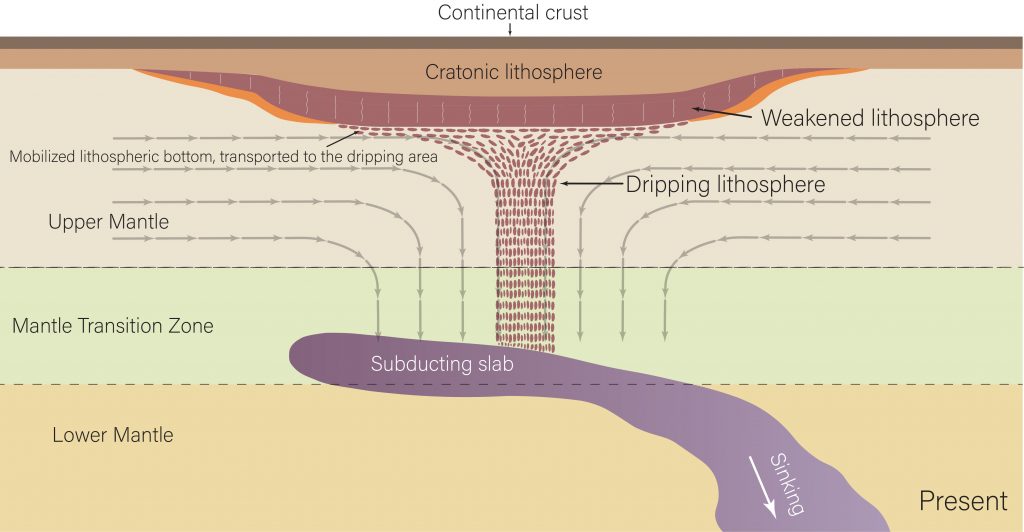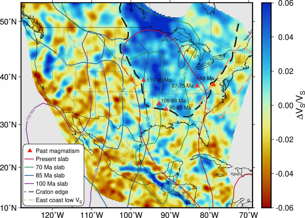
Researchers have discovered that the underside of the North American continent is dripping away in blobs of rock — and that the remnants of a tectonic plate sinking in the Earth’s mantle may be the reason why.
A paper published in Nature Geoscience describes the phenomenon, which was discovered at The University of Texas at Austin. It’s the first time that “cratonic thinning” may be captured in action.
“We made the observation that there could be something beneath the craton,” said the study’s lead author Junlin Hua, who conducted the research during a postdoctoral fellowship at UT’s Jackson School of Geosciences. “Luckily, we also got the new idea about what drives this thinning.”
Cratons are very old rocks that are part of Earth’s continents. They’re known for their stability and ability to persist for billions of years. But sometimes cratons undergo changes that can affect their stability or that remove entire rock layers.
For example, the North China Craton lost its deepest root layer millions of years ago.
What makes the discovery of cratonic dripping special, said the researchers, is that it’s happening right now. This allows scientists to observe the cratonic thinning process as it occurs.
The dripping is concentrated over the Midwest of the United States. There’s no need to worry about the continent hollowing out or the dripping changing the landscape anytime soon, the researchers assure. The mantle processes driving the dripping can influence how tectonic plates evolve over time – but they’re very slow going. What’s more, the dripping is expected to eventually stop as the remnants of the tectonic plate sinks deeper into the mantle and its influence over the craton fades.
The discovery is most important to geoscientists who study continents over their entire lifespan, said co-author Thorsten Becker, a professor at the Jackson School’s Department of Earth and Planetary Sciences and Institute for Geophysics.
“This sort of thing is important if we want to understand how a planet has evolved over a long time,” Becker said. “It helps us understand how do you make continents, how do you break them, and how do you recycle them [into the Earth.]”
The dripping discovery came out of a larger project led by Hua, who is now a professor at the University of Science and Technology of China, that created a new full-waveform seismic tomographic model for North America using an approach developed by co-author Stephen Grand, who is now a professor emeritus at the Jackson School, and his team. This computer model, which uses seismic data collected by the EarthScope project, revealed new details about the geologic processes happening in the crust and mantle underlying North America.

“Because of the use of this full-waveform method, we have a better representation of that important zone between the deep mantle and the shallower lithosphere where we would expect to get clues on what’s happening with the lithosphere,” Becker said.
This model brought the drips into view for the first time in this way. It also helped the researchers deduce that the Farallon Plate, an oceanic tectonic plate that has been subducting under North America for about the past 200 million years, could be driving the process despite being separated from the craton by about 600 kilometers.
The plate, which was first seismically imaged in the 1990s by Grand, played an important role in shaping the North American plate. The researchers think that it is now wearing away at the continent from below by redirecting the flow of mantle material so that it shears the bottom of the craton and by releasing volatile compounds that weaken its base.
Although the dripping is concentrated in one area of the craton, Hua said that the plate appears to be interacting with material from across the entire craton, which covers most of the United States and Canada.
“A very broad range is experiencing some thinning,” Hua said.
When the researchers built a computer model of these dynamics, the model craton dripped when the Farallon Plate was present. When the plate was removed, the dripping stopped.
Becker acknowledges that computer models have limitations. But the model’s resemblance to the data is a good sign, he said.
“You look at a model and say, ‘Is it real, are we overinterpreting the data or is it telling us something new about the Earth?,’” Becker said. “But it does look like in many places that these blobs come and go, that it’s [showing us] a real thing.”
The research was funded by the National Science Foundation and the Jackson School of Geosciences and involved colleagues at University of Hawai’i at Mānoa, University of Nevada, Reno, and Southern University of Science and Technology.
For more information, contact:
Constantino Panagopulos, University of Texas Institute for Geophysics, 512-574-7376
Anton Caputo, Jackson School of Geosciences, 210-602-2085
Monica Kortsha, Jackson School of Geosciences, 512-471-2241
Julia Sames, Department of Earth and Planetary Sciences, 210-415-9556.
